
With its incredible scenic views, nearly 300 days of sunshine a year, and long and winding roads, Arizona is a hotspot for motorcyclists seeking the ride of a lifetime. With so many different routes across the state to choose from, Arizona has a motorcycle trip to offer everyone- whether you’re in it for the views, the Wild West history, or just the thrill.
Motorcycle rides in Arizona are also extra special because, on any of these routes, you’re bound to encounter natural wildlife, including deer, cyote, elk, buffalo, eagles, turkey, and more.
Before starting any route, you’ll want to check with Arizona’s Department of Transportation site for real-time updates on road conditions.

The Grand Canyon Routes Provide Gorgeous Vistas
No Arizona motorcycling guide would be complete without a trip to the famous Grand Canyon. It’s no secret why this is one of the most popular motorcycling destinations in the world- who wouldn’t want to take a joyride to the single most scenic spot in the United States?
The Grand Canyon is an extremely historic landmark in Northern Arizona. It is believed to have formed anywhere from 5 to 6 million years ago when the Colorado River began to erode through layers of multicolored rock.
It runs a mile deep and spans 277 miles long. The earliest known human activity in the Canyon is believed to have started some 12,000 years ago, according to Knowable Magazine, and ancient enclaves are still being found by archaeologists to this day.
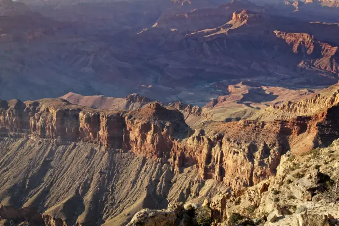
There are two main parts to the Grand Canyon- the North Rim and the South Rim.
The South Rim is the most traveled sector due to it having the best views of the canyon. It can get crowded, but most everyone agrees that the views make it worth it. From the South Rim, you even can see across the canyon all the way to the North Rim! You can access the South Rim in a few different ways.
The North Rim, however, is a better motorcycle ride. It is the only route that is enveloped in a national forest. Thanks to this, you won’t be as bothered by the noise and bustle of surrounding towns and tourists. There’s plenty of wildlife to see, sharp curves, and changes in elevation to awaken your thrill.
If you’re in it for the scenery, visit the South Rim. If you’re seeking a better ride, the North Rim is the sector for you.
Any trip to the Grand Canyon isn’t complete without a decent camera to take photos with. DSLR cameras like this Canon are perfect for landscape shots for newbie or experienced photographers.
The Route
South Rim: If you want to ride to the South Rim of the Grand Canyon, you can access the route from east or west on State Route 64. You will travel through a vast desert to arrive at Grand Canyon National Park.
North Rim: The North Rim only has one way in and one way out. To get to the North Rim of the Grand Canyon, you’ll start in the town of Jacob Lake. From there, you take Route 67 South all the way to the North Rim.
Note: Route 67 is closed during the winter, and often closes other times depending on road conditions. Make sure you call about road conditions before starting your ride.
Take Phoenix to Tombstone for a Western Experience
Are you a fan of old Western history and dying to walk the same historic streets in Tombstone walked by Wyatt Earp, Doc Holliday, and Johnny Ringo on your trip to Arizona?
This is the route for you.
Tombstone, or “The Town Too Tough to Die,” is perhaps the most famous site of Wild West stories and happenings. The famous O.K. Corral gunfight between the Cowboys and Wyatt/Virgil Earp and Doc Holliday happened here, and there are plenty of Wild West attractions in the town for fans to live out their own shootout experiences. You can:
- Watch a gunfight show at the Gunfight Palace
- Tour Tombstone’s first mines (dating back to 1878)
- Take a historic tour of Tombstone by stagecoach
Between the gunfight shows and mining excursions, Tombstone is the perfect destination for the Wild West-obsessed biker. Not only is it historic, however, it’s also incredibly scenic, with iconic Saguaro cacti and mountainous ranges lining the ride.
The Route
This 184-mile route takes you from Phoenix to Tombstone mostly via I-10 East. Keep right and onto Historic Route 80 E. Turn right onto S 6th St, left on Allen St. You can complete this route within four hours- many bikers enjoy making a day trip out of this route by eating lunch in Phoenix and dinner in Tombstone as a day trip.
Bartlett Dam Road to Bartlett Lake Provides a Peaceful Getaway
If you’re seeking a destination that’s more peaceful than the gunfights of Tombstone, try out Bartlett Dam Road to Bartlett Lake.
Bartlett Lake is a man-made lake that connects with the Verde River. With desert views and plenty of opportunity for fishing, camping, and hiking, it’s the ultimate destination for any outdoor enthusiast. It also has the added benefit that there are two towns nearby- Cave Creek and Carefree, which offer restaurants and spots to fill up on water.
From Bartlett Dam Road, you also can take a short one-mile hike to the Sears-Kay ruins in an old Hohokam Native American village.
The Route
The 14-mile winding road descends from the end of Cave Creek road all the way down to the Bartlett Lake Marina.
Note: The area this road spans tends to be especially hot (particularly in the summer), so make sure to bring an extra bottle of water and take ample time to cool off at your destination. I recommend a durable stainless steel water bottle for motorcycle trips.
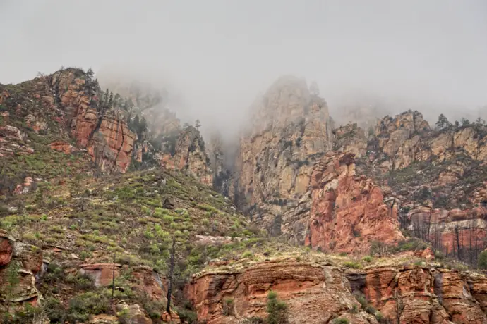
The Iconic Sedona Route is Perfect for Landscape Views
If your trip to Bartlett Lake had you overheating, cool down with this classic ride to Sedona. Being one of the most popular bike rides in the state, the road can be crowded for some parts of the year, but for good reason.
The scenery is considered to be one of the best in the state of Arizona, as the route travels through beautiful mountain ranges, open deserts, and lush woodlands. The road itself is high quality for riding, with steep descents and tight switchback turns for the adventurous rider. Be careful of rocks or cracks in the road though, as it is well traversed.
This road is a favorite in part due to the many changes in the landscape across a mere 30 miles. The road takes you through “Old Creek Canyon,” and there’s a fantastic cliff overlook you can stop at for a view of the canyon you’re about to be driving through. After you descend into the canyon, the climate gets warmer and drier as you go, and the plant life changes dramatically.
Not only is the ride itself enjoyable, but there are also plenty of outdoor excursions you can stop at as you travel.
- Stop at “Slide Rock State Park” for swimming at a natural waterslide during the warmer seasons
- Another great swimming opportunity is at “Grasshopper Swim Area,” a collection of creeks popular for wading and swimming
- For rocky water activities, make sure you have a good pair of water shoes to protect your feet.
- Endless hiking trails also line the canyon, so be sure to take some high-quality hiking boots with you. My personal favorite are these Columbias, thanks to their waterproof capability and quality.
The destination is the canyon outlined town of Sedona, a famous art town with plenty of opportunities for art viewing and gift shopping. It’s the perfect place to rest before beginning your return home.
The Route
The route for this destination is incredibly simple. You’ll want to take 89A South, starting from Flagstaff. The 30-mile road leads you directly towards Sedona. Or you can reverse that route, 89A North starting from Sedona and ending in Flagstaff.

The Apache Trail is Full of History
Another significant location on this list, the Apache Trail scenic drive (also known as Arizona State Route 88), is full of natural beauty and history.
According to TripSavvy, the Apache Trail “gets its name from the Apache Indians who originally used the trail to navigate through the Superstition Mountains.” After settlers arrived in the early 1900s, the route turned into a stagecoach passageway through that section of the Superstitions Mountains; but today it serves as one of the more popular scenic drives in Arizona.
One interesting fact about this trail is that it is not entirely paved, in fact most of it is gravel. Right around Tortilla Flat, the pavement disappears, and remains of the old dirt roads traversed by stagecoaches are the only thing that continues.
Tortilla Flat is now where this section of your motorcycle journey ends, actually you have to stop there now as they closed off the road in 2019 past Tortilla Flat due to a horrible fire and then a monsoon wiped out a good portion of the road and is closed until further notice.
The road is well maintained- challenging, but drivable with motorcycles and absolutely worth the effort.
There are diverse stops and excursions along the trail, making it a hotspot for bikers, families, solo travelers- you name it.
- Canyon Lake, is one of three lakes along the trail, and is perhaps the most scenic excursion. It’s well-outfitted with fishing spots, beaches, and campgrounds, and is a popular site for hiking, wildlife observation, and get this- scuba diving.

- The Tonto National Monument is a protected relic area of the Tonto National Forest, the forest that surrounds the Apache Trail. Here just off of 88, you can visit stone and rock residences of the Salado culture, who occupied the area during the 13th, 14th, and 15th centuries (Source: revzilla). You do have to come from the direction of Globe/Miami to access it.
- If you can chalk up a mere $3 on a weekend, you can get a guided tour of the upper quarters of these age-old masterpieces.
- Tortilla Flat, another popular stop-off, is a historic town built in the Superstition Mountains in 1904 that currently boasts a population of six total residents. You can stop at their single restaurant for a burger or visit the mercantile for some gift shopping.
- The Theodore Roosevelt Dam represents the end of the Apache trail, and it’s hard to miss. At 357 feet high, the towering structure signals riders to turn back the way they came. You have to access this relic from the direction of Globe/Miami.
The Route
The Apache Trail is a 45-mile paved and dirt stretch on State Route 88, off of US 60 from the East side of Phoenix. Again a portion of it has been closed after Tortilla Flat so access to parts of this iconic road has to be accessed from 2 sides. The other side of the route is off of State Route 188 via Globe/Miami.
Try Phoenix to Old Tucson for Arizona’s “Hollywood in the Desert”
While Tombstone may be the original site of the historic shootouts and residences of famous Wild West names, the famous movie ‘Tombstone’ was actually shot in Old Tucson, also known as “Hollywood in the Desert.” If you haven’t seen Tombstone, it’s an absolute must for any trip to Old Tucson. You can find a copy here.
In addition to Tombstone, plenty of other Western films and famous television shows have been shot in this city, such as Little House on the Prairie, 3 Amigo’s, Rio Lobo,’ ‘El Dorado,’ and more, making it an absolute must-see for Western film fans. I’m actually not a western fan, but still really enjoyed touring it.
Thanks to this location being a tourist hotspot, there are endless Western cinema-themed attractions at Old Tucson to look forward to at the end of your ride.
Old Tucson is both family and solo friendly. Once you purchase admission, you’ll be met with actors and actresses who interact with visitors, and just like Tombstone, you’ll be able to see gunfight shows (they will be more theatrical in Old Tucson). You can also ride in antique cars and visit the movie museum.
The road from Phoenix to Old Tucson is a more casual ride than some of the others. You take an interstate the whole way through, so you don’t need to focus on managing sharp turns and steep inclines- just sit back and enjoy the scenery on your way.
The Route
Starting in Phoenix, you’ll get onto I-10 East for about 92-miles. Take exit 236 toward Marana Rd. Turn right onto N Sandario Rd, turn right onto W Marana Rd. Turn left onto N Sanders Rd. Turn Left onto W Avra. Turn right onto N Sandario Rd. Turn left onto W Mile Wide Rd, make a U turn and you’re there. It takes about two hours to arrive at Old Tucson from Phoenix and it’s a very pretty drive especially once you get off of the freeway.
Visit Kofa National Wildlife Refuge for a Wildlife Getaway
Heading in the opposite direction from Phoenix on 1-10, you’ll find yourself at Kofa National Wildlife Refuge, a part of the National Wildlife Refuge network.
This piece of land is open to recreational visitors and is home to a vast number of wildlife creatures in the scenic Yuma Desert region of the Sonoran Desert. This ride is perfect for lovers of animals and nature.
It is a secret gem. It’s quite remote; and while it is open to visitors 24 hours a day 365 days a year, it is less traversed than other popular wildlife areas, allowing for the privacy of its visitors.
There are 666,640 acres of land on the refuge, and 547,719 of those acres are designated as ‘wilderness’ (Source: U.S. Fish and Wildlife Service), making it the second-largest wildlife refuge in the state. It has one of Arizona’s largest populations of bighorn sheep, and various types of pronghorn as well.
On the interstate ride to the refuge, you’ll pass scenic mountain ranges, open desert, and plenty of cacti. Upon arrival, there are plenty of opportunities for hiking in the wilderness, wildlife photography, and even camping. Experiencing gorgeous scenery on the way to and at the destination? Sign me up!
If you’re looking for an opportunity to experience the true Wild West, give the scenic ride to Kofa a try. For the best wildlife viewing experience, quality binoculars like these are a must.
Note: The wildlife refuge becomes extremely hot in the summer, so it’s best to take this ride during the cooler months.
The Route
From Phoenix, you’ll take I-10 West to just before Quartzsite, where you’ll take a left onto 95 South. The trip is 160 miles long, lasting an easy 2.5 hours one way.
Visit the Beautiful Tonto National Forest through the Mesa, Globe, Punkin Center, and Back to Mesa Loop
Kind of a mouthful, huh?
This loop will take you and your ride from Mesa, to Globe, to Punkin Center(Payson) in the Tonto National Forest, all the way back to Mesa. It’s one of the longer rides on this list, so if you’re not used to riding for extended lengths of time, you may want to invest in a plush motorcycle seat cushion to save yourself from a sore bottom.
That said, the terrain itself is extremely mild. So if you’re not comfortable with challenging routes but want to take your ride out on the road for a long trip, try this loop. Soft corners and light traffic on the roads means this route is perfect for cruising- a true joyride at its best.
The best part of this route is the scenery at the Tonto National Forest, where you’ll pass by fantastic views of the Theodore Roosevelt Lake and the Tonto Basin. Here, you can stop for some landscape photography, and there are hiking/camping opportunities along the route.
- If that speaks to you, portable camping tents like this are perfect for spontaneous camping on the road!
And when you’re ready for dinner, there are restaurants at Punkin Center for you to stop and enjoy after a long ride. There’s even a popular biker bar there called the ‘Punkin Center Bar and Grill’ for you to crack open a cold one with the boys (and girls) at.
Riders who have reviewed this loop have noted that the weather changes from cool in the mornings to pretty hot in the afternoons on the way back to Mesa, so be prepared with a quality jacket that you can wear over cooler clothes and store elsewhere as it gets warmer.
The Route
This 203-mile loop begins in Mesa. From there, you’ll head East on US 60 until you hit Globe. You’ll then take a left onto AZ 188, hit Punkin Center, and then mosey back on to Mesa on 87. The entire excursion should take you no more than 4 hours to complete.
The Phoenix to Prescott (through Wickenburg) to Phoenix Loop Provides a Challenge for the Seasoned Biker
This is another 200-mile fantastic loop, taking you from Phoenix to Prescott and back to Phoenix. On your way to Prescott, you’ll pass through Wickenburg, known to some as ‘The West’s Most Western Town.’
The initial 40 miles towards Wickenburg take you through the open desert road with minimal traffic, an easy start to the trip. Once in Wickenburg, you can experience a truly historic town that maintained its Western charm while providing a modern community for residents today.
Wickenburg was discovered by Henry Wickenburg in the late 1800s searching for gold, and he struck lucky. Hundreds of thousands of ounces of gold and silver were discovered in the Vulture Mines there (Source: Town of Wickenburg), increasing the number of settlers who came to the region.
Passing through this town today is like taking a trip back in time, making it the perfect stop to rest at and explore along this extensive loop. You can find an informative video about what Wickenburg is like today from a seasoned road-tripper here.
Once past Wickenburg, you’ll begin climbing 5,200 feet up towards Prescott. As the incline increases, so do the twisting turns. This is where the loop is either challenging or enthralling, depending on your comfort level. This road is far less traversed by cars than others, so bikers have the freedom to carve through the expanse at their pace. This is a truly thrilling ride.
Due to the nature of the road at this point, it’s important to remember not to go too fast, and never to attempt this loop during the winter months.
The winding road up to Prescott will take you past breathtaking views of mountain ranges and valleys (and here’s a pro tip: they look even better at sundown).
Once you reach Prescott, you’ll take a different route back to Phoenix in which the curves are milder and the road is less dangerous- a nice break from the concentration that was required of you on the way up.
This loop is generally intermediate, but the incline up to Prescott is challenging without a doubt. If you’re seasoned in riding, however, the Phoenix New Times calls this road a “gift from the motorcycle gods.”
The Route
This 200-mile loop begins on US 60 from Phoenix. You take US 60 for 40 miles until you hit Wickenburg. After departing Wickenburg, you’ll take a slight right onto State Highway 89.
The fun begins here, and after you’ve completed 60 miles on that curving road, you’ll have made it to Prescott. From there, head back East on State Highway 69, which eventually meets Interstate 17 for a straight shot back to Phoenix. This loop should take anywhere from 4 to 5 hours depending on traffic.
The Bisbee Loop has Something for Everyone
For the last bike ride on this list, we’ll take you on a short and exciting loop through Bisbee. This loop takes you on a scenic ride with inclines, descents, and tunnels- then takes you back through green pastures with the Huachuca mountain ranges in the distance, passing Miller Peak.
Bisbee offers a fun downtown experience for you to enjoy in the middle of your loop ride, and truly has something for everyone.
Founded in the late 1800s, it’s a historic mining town that has transformed into a bustling urban location for seekers of art galleries and shopping opportunities. It’s also filled with tons of varying cafes and restaurants, allowing you to cater your dining experience to your liking.
Historic Bisbee was “one of the richest mineral sites in the world,” and is still home to a lot of Arizona’s “firsts,” including:
- The oldest ballpark in the nation (Warren Ballpark)
- Arizona’s first golf course (Turquoise Valley)
- Arizona’s first community library (Copper Queen)
(Source: Discover Bisby).
History fans will also have access to Bisbee’s Mining and Historical Museum.
If you visit Bisbee during the night hours, don’t give up on a chance to experience Bisbee nightlife! With plenty of bars and saloons to choose from, you’re bound to find a drink and a crowd that suits your fancy.
Bisbee is also one of the coolest parts of Arizona, meaning it’s the perfect place to ride to during the hotter months.
Clearly, Bisbee is a wonderful stop for any rider to enjoy on their short and fun loop around the city.
The Route
This loop is an approximately 60-mile loop beginning in Sierra Vista. Begin by heading down Highway 90 East until you merge onto Highway 80. From here, you climb up to Mule Pass, and then a long cruising descent down into a tunnel. You’ll reach Bisbee, have a wonderful time, and then take Highway 92 West all the way back to Sierra Vista. The whole loop will take you no more than an hour and a half.
It’s no wonder Arizona is famed as one of the best spots to motorcycle in the nation. From the challenge of climbing from Phoenix to Prescott to the gorgeous scenery of Sedona, all the way to a fun short loop around downtown Bisbee, I’ve hopefully recommended a motorcycle route that suits the tastes of every biker- beginner, intermediate, or experienced.
No matter what, never forget to check with Arizona’s Department of Transportation for road conditions before departing to avoid any unpleasant experiences or accidents. Have fun and ride hard!