
Have you ever heard of Chiricahua National Monument? Are you planning on visiting or would you like to plan a visit to Chiricahua National Monument? Here are 5 tips before visiting Chiricahua National Monument.
Arizona is undoubtedly home to some of the country’s most well-known national parks, but many of the state’s most unique landscapes and beautiful views will be found within its lesser-known areas. Chiricahua National Monument is the perfect example of an Arizona hidden gem. This national monument is located in the midst of an Arizona sky island bursting with mind-bending rock formations, scenic hiking trails, unique wildlife, and the stories of many generations before us.
While Chiricahua National Monument’s remote location has rendered it one of the twenty least visited parks and monuments in the western United States, this article will explain exactly why it’s worth the trip! Read on to find out more about what Chiricahua National Monument is known for, must-see spots, hiking trails, park/campground information, and nearby accommodations.
1. What is Chiricahua National Monument known for?
Chiricahua National Monument, also known as “The Wonderland of Rocks”, is nestled among the Chiricahua Mountains in southeastern Arizona, roughly ninety miles east of Tucson near the town of Willcox, Arizona. The national monument was established to protect the magnificent, towering rock spires that define the surrounding landscape.
The monument offers travelers scenic drives, guided tours, and over fifteen miles of day-trip hiking trails. Best known for its geologic formations, bustling wildlife, and rich history, Chiricahua National Monument is sure to captivate each and every traveler that pays a visit.
Geologic Formations
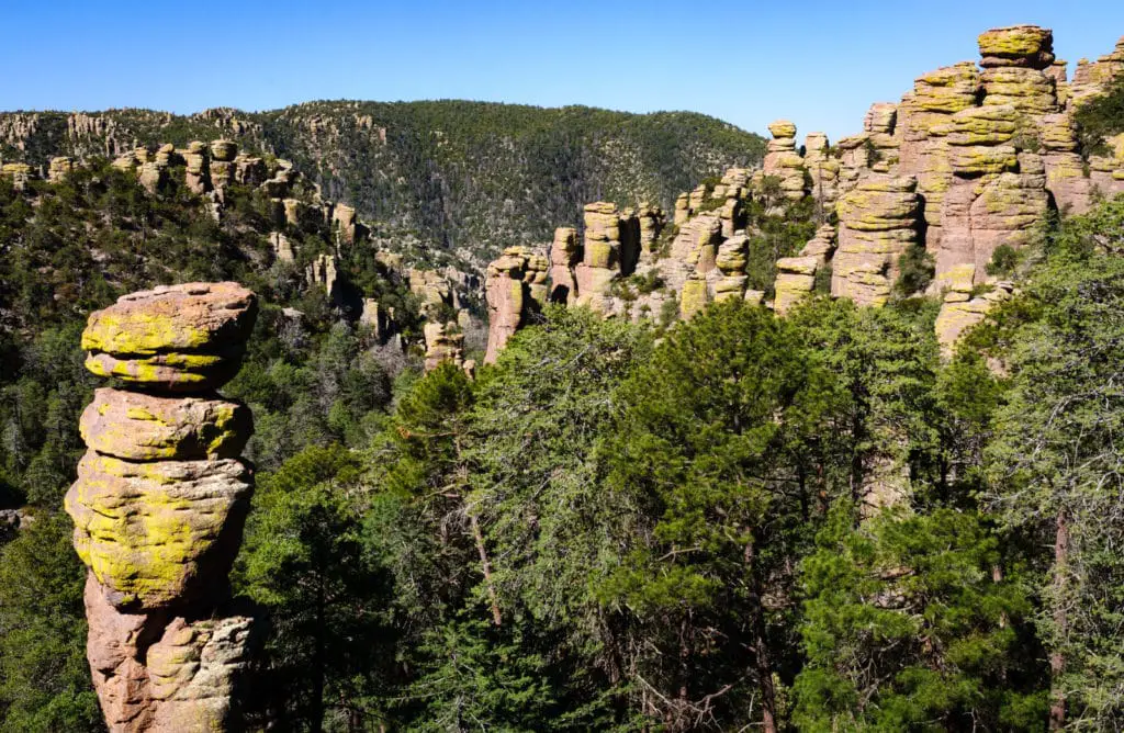
If you come to Chiricahua National Monument for only one reason, chances are it will be to take in the vision of the rock pillars leftover from a volcanic eruption that took place over twenty-seven million years ago. These formations are exactly what the national monument was established to showcase and protect in 1924. Far before humans existed, a volcano at Turkey Creek erupted over the surrounding land that would someday become Chiricahua. The ash from this volcanic eruption fell down to the earth below, forming into volcanic rock over time. Throughout history, large chunks of the rock have fallen away, leaving unusual natural features standing up to several hundred feet in height in its wake. These geologic formations define Chiricahua National Monument today.

When the Apache Indians lived among this area, they referred to Chiricahua as “Land of the Standing-Up Rocks.” Take one look at the landscape and you will understand the reason for this matter-of-fact nickname. These bizarre-looking geologic formations are known as rhyolite rock pinnacles. Often, these columns appear to have massive boulders balancing high in the sky on a tiny rock base that could topple over at any moment. Don’t worry, they won’t! But they may very well make you feel like you’re visiting another planet or traveling back in time.
Because of its unique geologic makeup, the park also showcases several natural vista points over the surrounding land, as well as mountain ridges, ancient lava flows, water springs, small caves, and one massive volcanic crater just south of the park. As you hike and drive around, you will hear about many different must-see rock formations. Some of the most popular are Organ Pipes, Big Balanced Rock, The Old Maid, Camel’s Head, Sea Captain, China Boy, Duck on a Rock, Punch and Judy, and Thor’s Hammer. Where did these funny names come from, you ask? The Civilian Conservation Corps named many of the rock formations that can be seen today while they were stationed at the park in the 1930s. The Conservation Corps also built the park’s campground and stone mason visitor center.
Wildlife and Bird Watching
You may hear Chiricahua National Monument referred to as a sky island; this is a term for an isolated mountain range in an otherwise flat, desert-like land. Due to this geologic phenomenon, you will find varying conditions and ecosystems as you go from the bottom to the top of Chiricahua National Monument. The bottom-areas of the park have higher temperatures, less precipitation, and a dryer environment. Yet, as you climb to the top you will notice that the temperature decreases the higher you get. The top-areas of Chiricahua experience far more weather patterns than the bottom and therefore have more mild temperatures during the summer months, but can become very cold in the winter. You will be able to experience desert, grasslands, dense forests, and mountains and plains all without leaving the park!
Each of these ecosystems comes with its own unique wildlife, meaning Chiricahua hosts a fascinating combination of animals and birds that you’d be hard pressed to find coexisting otherwise. Roughly 86% of Chiricahua’s land has been federally designated as wilderness to allow everything from black bears to wild turkeys to roam freely without human interaction. However, you will still be able to see your fair share of wildlife within the permitted areas.
Chiricahua National Monument is also home to a vast number of bird species and has been certified as an “Important Bird Area” by the American Bird Conservancy. In addition to the monument’s southern location bringing many Mexican bird species across the border, Chiricahua is also a natural pit-stop for birds flying north or south on their yearly migrations. For this reason, there are always interesting birds to search for at the park. Commonly seen birds include the Mexican Jay, Acorn Woodpecker, Canyon Wren, White-breasted Nuthatch, Northern Flicker, and Turkey Vulture. If you’d like to test your spotting skills while visiting, be sure to check out the Chiricahua Bird Checklist!
History
Chiricahua National Monument has the history buffs covered as well. The monument has quite a diverse human history.Chiricahua Apache Indians are known to have lived among this land far before early pioneers arrived in the 1860s. The Chiricahua were made up of various Apache tribes who settled in what is now northern Mexico, the southeastern corner of Arizona, and parts of southwestern New Mexico. As nomadic people, the Apache Indians lived off of the land and moved from lower to higher altitudes depending on the time of year and weather patterns. Descendants of these native tribes still live in the area today.
From the 1860s through the mid-1880s, early pioneers began to show up in the Chiricahua Mountains and battled with the Apache tribes, who were led by the famous chiefs Cochise and Geronimo, before fully taking over. During the Geronimo campaign, Buffalo soldiers of the 10th Cavalry were sent to fight here. During your visit, you can take a moment at the Garfield Fireplace which serves as a monument dedicated to these soldiers inside of the park.
After 1886, early pioneers settled in and around Chiricahua and Bonita Canyon. Structures built by these settlers are preserved around the park today. Two of the most famous families who lived inside of what is now Chiricahua National Monument are the Erickson and Stafford families. You can learn more about them by visiting the Faraway Ranch and Erickson Cemetery inside of the park. Guided tours of the Faraway Ranch Historic District are provided every Saturday and Sunday. Additional dates are added during spring and summer seasons.
2. What are the top spots to see in Chiricahua National Monument?
Here are some of our top recommendations for what you can’t miss in Chiricahua National Monument.
Heart of Rocks
If you’re an average traveler who would like to get the most bang for their buck, be sure to check out the Heart of Rocks Loop. Stemming off from the Lower Rhyolite Canyon and Sarah Deming trails, the Heart of Rocks Loop is an easy walk that shows off many of the most unusual rock formations in the monument. This trail will take you up close to see a wide array of the famous rock formations Chiricahua is known for, including several examples of the mind-bending balanced rocks. Be sure to bring your camera and shoes to climb around in!
Massai Point
Looking for sweeping views and picturesque landscapes? Massai Point is your must-hit destination. This vista point allows visitors a 360-degree panoramic view to gaze deep into the canyons and out into the distance. Not only is this high plateau accessible by roads and trails, but Chiricahua National Monument also offers a free shuttle that will drop you steps away.
If you’d like to drive yourself to Massai Point, we can’t recommend the Bonita Canyon Scenic Route enough. This eight-mile paved road will take you right to Massai Point. However, the journey is just as enjoyable as the destination! You will come across multiple pullouts to enjoy the scenery as you drive.
Faraway Ranch Historic District
You’ve got to visit Faraway Ranch Historic District to get the full picture of what life was like for the settlers who lived their lives in Chiricahua National Monument almost two centuries ago. Here, you will get the opportunity to step inside the historic Faraway House, which was the home of the Erickson family. This Swedish immigrant family created an entire ranch to host and entertain guests. Many of these structures, as well as a historic cemetery, the Stafford family cabin, work barns, and a horse corral are still standing today for visitors to admire while they ponder the lives of these people that lived here long ago. For those who really want to dig deep into the history, we recommend taking a guided tour of the Faraway Ranch Historic District with a park ranger!
3. Hiking/Trails Information
Chiricahua National Monument spreads out over seventeen miles of canyon land and offers over a dozen day hikes that range from easy (0.2 miles with little elevation change) to strenuous (9.5 miles with elevation changes of 500-1000ft). Each and every hike offers something spectacular. Here are some of our favorites:
Easy Hikes
- Bonita Creek Loop: a quick 0.2 mile loop around the picnic area with great views of wildflowers in the spring and summer, as well as wildlife and grassland birds year round. Pets permitted.
- Massai Point Nature Trail: 0.5 mile trail at a slightly higher elevation that will lead you to stunning views of the surrounding peaks and valleys. Pets not permitted.
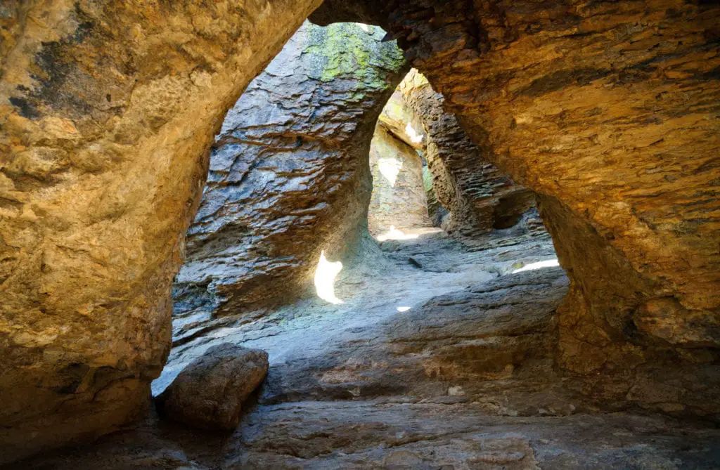
- Echo Canyon Grottoes: 1.0 mile round-trip walk among the rock formations– a great option if you don’t have time to spare for the full Echo Canyon Loop hike. Pets not permitted.
Moderate Hikes
- Natural Bridge Trail: 4.8 miles round trip, this hike will take you through oak and juniper woodlands and down into the Apache pine forest of Picket Park. You will end up at an overlook for the small water-carved bridge located across the canyon. Pets not permitted.
- Sugarloaf Mountain Trail: 1.8 miles round trip, this trail will guide you above the surrounding canyons to the summit of Sugarloaf Mountain. At the top, you’ll find yourself taking in views from one of the highest points in the monument. Climb up into the fire lookout and take it all in! Pets not permitted.
- Echo Canyon Loop: a 3.3 mile loop through Echo Canyon, Hailstone, and Ed Riggs trail. This is one of Chiricahua National Monument’s most popular hikes! You will get an up close look at the Grottoes and Wallstreet rock formations, as well as the dense forests of Echo Park and desert plants of Hailstone. Pets not permitted.
Strenuous Hikes
- The Big Loop: a 9.5 mile loop that will show you absolutely everything: Echo Canyon, Upper Rhyolite Canyon, Sarah Deming, Heart of Rocks, Big Balanced Rock, Inspiration Point, Mushroom Rock, and Ed Riggs trails. This is an all-day expedition; hikers should be well-prepared with snacks and plenty of water before setting out on this loop. Pets not permitted.
It is worth noting that many of the stops on The Big Loop are options for shorter strenuous hikes within themselves. Talk to a park ranger or consult the Chiricahua Hiking Guide to find out about trails that will guide you to specific difficult-to-reach (but well worth it!) areas if you don’t have the time or resources for the full 9.5 mile Big Loop.
The park’s visitor center operates a free hiker shuttle daily from September to May that departs at 9:00am. This shuttle will drop off hikers at the Echo Canyon or Massai Point trailheads to hike back to the Visitor Center. You can sign-up for the shuttle by calling ahead or dropping by the visitor center the day before or morning of your hike. Shuttle capacity is 14 people and availability is on a first-come, first-served basis.
Rest assured, Chiricahua National Monument will mesmerize you no matter which hike you decide to take! Before setting out on a hike of any size, always make sure you’ve reviewed the National Park Service and/or park ranger guidelines and regulations.
I Hike For Health Pin
For those with a competitive edge, keep in mind that Chiricahua National Monument is one of five southeast Arizona parks where travelers can earn an I Hike for Health pin! The I Hike for Health program is a hiking challenge that park-visitors can complete on their own or with others. To earn the pin, each hiker must hike a minimum of 5 miles inside of Chiricahua National Monument and be able to provide a photo or selfie of themselves on each trail hiked. After completing the challenge, stop by the visitor center and talk to a park ranger to get your pin.
4. Park and Camping Information
Monument Entrance Fees and Open Hours
If you decide to make the trip to Chiricahua National Monument, you can work off of your own schedule. The monument is open every day of the year and does not charge an entrance fee. However, if you’d like to check out the visitor center, it’s open daily from 8:30 am to 4:30 pm MST. Inside, you will find exhibits about the monument’s geology, natural and cultural history, and archeology. There is also a short video that gives an overview of the park and a bookstore with everything from Apache history books to fun (yet educational!) children’s books.
If you would like to picnic inside of Chiricahua National Monument, check out the Bonita Creek and Faraway picnic areas for tables, grills, trashcans, and restrooms. If you’re out and about, you can find tables and restrooms at Massai Point, Echo Canyon, and Sugarloaf as well. Fresh water is provided for visitors at Faraway Ranch and the visitor center.
Campground Reservations and Campsites
Bonita Canyon Campground is located inside Chiricahua National Monument underneath the shade of a pine and oak forest. This campground was originally built by the Civilian Conservation Corps in the 1930s and contains twenty-five individual sites and one group site for up to twenty-four people. Flush toilets and potable water are available. Please note that Bonita Canyon Campground does not permit ground fires or firewood collecting, but visitors are welcome to bring their own fire pits and firewood from outside of the park.
Travelers looking to camp must make reservations for the campground through the National Reservation Recreation System over the phone at 1-877-444-6777. Each campsite is $20 per night, or $10 per night for those who carry an America the Beautiful Annual Pass and/or Federal Recreation Lands Senior and Access pass.
Chiricahua National Monument does not permit backcountry camping inside of the park. If you are interested in obtaining a backcountry camping permit for the surrounding area, check out Coronado National Forest for those opportunities.
5. Where to Stay
If you are not keen on camping out, fear not! Chiricahua National Monument is an easy day-trip from Tucson, a major Arizona city with dozens of hotels and accommodation options. Looking to stay closer to the park? The town nearest to Chiricahua National Monument is Willcox, Arizona. There, you will find a handful of hotels and restaurants to choose from. If you’re heading west from the monument, check out Tombstone, Arizona. Accommodation options in Tombstone include Trail Rider’s Inn Motel, Tombstone Sagebrush Inn, and Budget Host Inn Tombstone.
Airbnb also offers several listings near the Chiricahua National Monument and Chiricahua Mountains– ranging from “glamping” in tipi huts to guest houses and cottages.
Whether you end up camping onsite, lodging in town, or just swinging by for a day trip, rest assured that you won’t regret stopping to take in the grandeur of Chiricahua National Monument. In fact, you’ll likely find yourself wondering why this isn’t one of Arizona’s most known parks!